Little Rock Gangs
Map & Breakdown of the Little Rock Hoods
During the 1980s and 1990s, Little Rock gangs started emerging in a different way, resembling Bloods and Crips, as well as the Gangster and Black Disciples from Chicago. These gangs spread across various neighborhoods of Little Rock, including North Little Rock, the East End, West Side, and South End.
While the 1980s brought the Bloods in ‘hoods like Highland Park, which was one of the first areas to have a gang affiliation, much has changed since the time when the streets within the Little Rock ghetto witness gang bangin’ at its peak. Even though some people are still gang affiliated, gang activity has become less active in the streets since the 2000s.
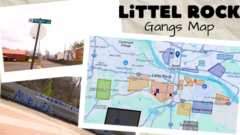
Little Rock Gangs Map Key: Red = Bloods | Blue = Crips & Disciples (GDs/BDs) | Black = Unknown
*Make Sure To Leave a Comment, especially if something is wrong or missing
Breakdown of Little Rock Hoods & Gangs
The heart of the Little Rock’s metropolitan area expands from S. University Ave. to the Clinton National Airport, or from the West End to the East End. Before segregation came to an end, the city’s black community was based in sections of the South End and the city’s East End, mostly east of today’s Doctor Martin Luther King Drive.
When construction was booming around the city of Little Rock during the 1970s and 1980s, the inner city of Little Rock started to become predominantly black, from the West End to the East End, as white flight was moving people, businesses, and a tax base towards West Little Rock.
With the arrival of gangs in a number of Little Rock hoods, the Bloods dominated from John Barrow (Lime Hood) to the once Highland Park projects, to the East End’s Brick Jungle (Hollingsworth). The only Little Rock gangs being under the Crip affiliation were areas like College Station and 23rd and Wolfe Street.
While urban renewal changed and destroyed much of the East End, with the construction of housing projects, the airport, and highways I-630 and I-30, today the urban community and its residents are moving further from the central part of Little Rock into areas and sections of the West Side or Southwest Little Rock.
North Little Rock Hoods
Across the Arkansas River resides the streets of the North Little Rock, an area of neighborhoods like Eastgate, Off Pike, or Shorter Gardens to go with Little Rock gangs of the Black Disciples and the Gangster Disciples.
The city of North Little Rock began growing between the 1940s and 1960s with the original black community of North Little Rock being east of I-30 in communities like Dixie or Rose City, around Broadway and Lynch. The growth of North Little Rock’s urban communities continued during the 1960s and 1970s and expanded into areas like Pike Avenue or Camp Robinson Road, dividing North Little Rock into separate sections DTA and UPT.
one of the founders of Highland Park Murder Mob was started by a St Louis Crenshaw Mafia Blood OG Rumble from West Side 57 KMob in STL back in the mid 1980’s 💪🏾👌🏾🩸
For some reason I would like to know what the reason for the lager black area is of saying unknown. If thats the case way is the other portions of this article’s saying there known.
19th street Wolfe street Crips was started by a guy from Laclede town in St. Louis, he was a 19th Long Beach Crips and he had moved down to Little Rock from St. Louis and started 19th street Wolfe street Crips back in the early 90’s his name was OG D-Bird he out now he was related to C-Style from Long Beach California one of snoop dogg guys
Pettaway Area is BSVG. They’re east of Broadway. That area isn’t considered the south. It’s on the other side of Roosevelt.
True though
This prolly from back ina day I was finna say that to cuz south is free way to fairgrounds
1700 E 21st Street supposed to be bloods
Jacksonville consists of BD/GD primarily GD but it’s some BDs in jville, really jville folk nation ain’t too many mfs claiming other sets or gangs in the ville. 2-4 From the ville, 16 to all my folks 2-15-19
LETS GO CRIPS !!!!
Fam 65th Street Is (Blood , GD, Crip and The 13’s)
Black squares are the Banditos!!!
LETS GO LATIN SKINS
THIS IS RACIST WE ARE NOT “Black Disciples” YOU G*Y F***ING VULTUREZ. #BLACKLIVESMATTER
The Black Disciple Nation is a gang that originated in Chicago during the 1950s or 1960s
Lol lmao dude thought he had something
mannn what
NLR AR NEW GANG TAG SEEN “LATIN SKINS”
FOR REAL MANNNN
I don’t think you should tie in the crips and Folks cause there neighborhoods are very different as the man below said. North Little Rock majority of the time is going to be BDs. There’s some GDs in the mix too but mainly in Levy and Dixie. Jacksonville is also primarily GDs in New Town. Southwest has some Gs but in small areas like Valley Dr other than that southwest is primarily bloods and Latin Kings. The bloods are probably the biggest in Little Rock. You got the old Highland Park Pirus when it was still standing, 5 deuce Brims in Granite Mountain, Murder Mob in Hanger Hill, and Lime Hood Pirus in John Barrow. There are also Original Gangster Crips in Southwest and spread around and Neighborhood Crips on Wolfe Street. Not to mention the Vice Lord’s on Roosevelt and around 12th street.
Fam , Grantie Mountain Has Always Been Piru , When They Switch To Brims ?
Granted mountain was crips b4 anything
Surprisingly Chicago gangs didn’t take Over bloods n crips a children’s gangs no laws no literature nothing
There used to be a lot of 4 Corner Hustler Vice Lords in Granite Mountain in the PJs from what I remember.
They never been piru n they 6 duece not 5
What you said
Murder Mob is Highland Park/W. 12th. Hanger is Hilltop Hustlers. I do know at least 1 person FROM Hanger that claims Mob, but that’s because he used to hang around on 12th.
It ain’t never been no damn murder mob in hanger hill it’s only one person was claiming HTH n mob n that was a family tie
This is not accurately correct, bcuz before any of this, 4Trey GC was the first Crips set in not only LR but originally founded in Southwest LR on the corner of 43rd and Valley Dr. The OG name will not be mentioned but I do know this history as a 30 year member myself
What it matter if y’all already a gang , police ain gone look at that shit different
4 Trey Gangsta Crip aka Storm 💙 OG B Holly